 Day#1: Boise to Keno via Christmas Valley and Silver Lake was 426 miles/9:17 hours. We droned west on I-84 before switching to a slower than anticipated SH-20 due to road construction from Notus to Parma. Stopped at the Starlite Cafe in Vale for a good lunch followed by fuel at the Sinclair next door.
 Was a fairly cold, windy ride to Burns. Got drenched by a rainstorm on US-395 until we turned off on Christmas Valley-Wagontire Rd. The Chevron in Christmas Valley was pretty busy for a hamlet in the middle of nowhere. Silver Lake Rd to US-97 was the most enjoyable part of our ride although it sure was getting chilly out. US-97 to Klamath Falls was a cold, semi-truck saturated snoozer. We stopped for great supper at Hidalgo's Authentic Mexican Restaurant in downtown Klamath Falls.
 Keno, OR: We stayed at CasaRawJoy, located on top of a hill, that Thursday enroute to Fortuna and that Sunday on way back to Boise.
 Keno, OR: View from backyard of CasaRawJoy near Klamath River.
 Klamath, CA: We did this spontaneous counterclockwise Klamath Beach Rd/Alder Point Rd loop while southbound on US-101 to Trinidad. Was climbing uphill on a semi-gnarly dirt section with stunning views of the coast. We didn't stop as I was in the "we gotta get outta here" mode. ;^)
 Trinidad, CA: Trinidad Memorial Lighthouse overlooking Trinidad Harbor. This was a much smaller town (~300 ppl) than we had anticipated. Absolutely gorgeous out there on a cold, windy day.
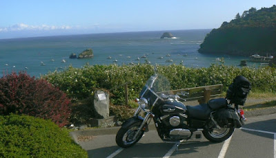 Trinidad, CA: Obligatory photo of our steed overlooking Trinidad Harbor.
 Trinidad, CA: Quiet, isolated beach to left of the pier.
 Trinidad, CA: Trinidad Pier as seen from outside the Seascape Restaurant where we grabbed an early supper before riding non-stop to Fortuna for the night.
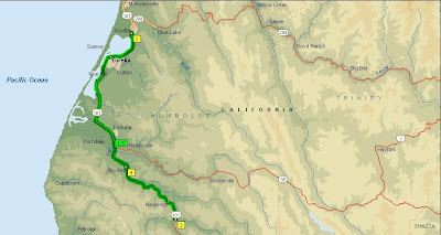 Day#3: Fortuna to Arcata then down to Avenue of the Giants and back was 103 miles/2 hours.
 Arcata, CA: Kate took the 90-minute guided tour of Humboldt State University which seems to be her college of choice. We grabbed a late lunch at the Golden Harvest Restaurant in town, and took a walking tour afterwards before heading south to Avenue of the Giants.
 Avenue of the Giants: Headlight seen in distance is Grumbler riding north through the redwood canopy.
Avenue of the Giants: 5 sec video shot by Kate as Grumbler blasts by.
 Avenue of the Giants: Northmost part of this road near Pepperwood just before the US-101 on-ramp.
 Avenue of the Giants: A view looking upwards at the 346' Founders Tree which is 1300-1500 years old.
 Fortuna, CA: Eel River as seen at dusk from our 3rd story room at the Comfort Inn.
 Day#4: Fortuna to Keno via Mount Shasta consumed 336 miles/6:37 hours.
 Willow Creek, CA: Bigfoot Museum was an interesting place in addition to being nice and cool inside although their t-shirts were lame.
  Weaverville, CA: Mike Plant joined us here at lunch at the Nugget Restaurant, and accompanied us for rest of day until the ignition switch on his FJR1300AE took a dump in Klamath Falls.
 Highway 3: Northbound in the Trinity Alps while riding from Weaverville to Callahan.
 Highway 3: Grumbler and Kate on the tight downhill stretch towards Callahan.
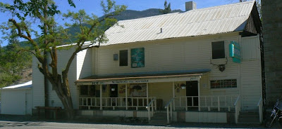 Callahan, CA: Historic old building, seen from across the street, which has convenience store and saloon.
 Callahan, CA: Kate and Mike with the bikes taking a break in the shade with cold ones.
 Callahan, CA: Close-up of the map located on front of the store. We took Gazelle-Callahan Rd east to Old Highway 99 and I-5 to Mount Shasta from here.
 Old Highway 99: Mount Shasta as seen on Old Hwy 99 south of Gazelle while enroute to I-5.
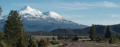 US-97: Grumbler and Kate northbound on US-97 with Mount Shasta in the background.
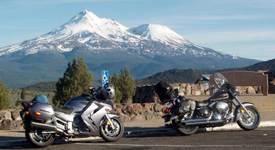 Mount Shasta: We pulled off US-97 at this viewpoint for a butt break before continuing north to Keno and Klamath Falls.
 Day#5: Did the Keno to Klamath Falls loop twice that early afternoon before heading back to Boise at 3pm PST. We arrived home at 11:30pm PST. Altogether, that was a 463 mile day.
Summary of fuel costs by location, price, gallons, and mpg
which varied by speeds, weather, et al. 90+ octane only.
6/5/08:
Vale, OR (Sinclair) $4.269 - 2.099 gals 42.93 mpg
Hines, OR (Chevron) $4.389 - 3.319 gals 34.71 mpg
Christmas Valley, OR (Chevron) $4.449 - 3.140 gals 33.09 mpg
Klamath Falls, OR (CHevron) $4.499 - 2.600 gals 46.85 mpg
6/06/08:
Phoenix, OR (Circle "K" 76) $4.439 - 2.312 gals 33.13 mpg
Crescent City, CA (Patriot) $4.759 - 2.664 gals 45.91 mpg
6/7/08:
Arcata, CA (Shell) $4.799 - 3.157 gals 44.22 mpg
6/8/08:
Eureka, CA (Shell) $4.759 - 2.630 gals 40.15 mpg
Weaverville, CA (Chevron) $4.779 - 2.418 gals 43.42 mpg
Weed, CA (Chevron) $4.879 - 3.003 gals 38.76 mpg
6/9/08:
Klamath Falls, OR (Chevron) $4.499 - 3.429 gals 41.14 mpg
Lakeview, OR (Chevron) $4.519 - 1.825 gals 51.45 mpg
Hines, OR (Chevron) $4.509 - 3.517 gals 39.15 mpg
Caldwell, ID (Chevron) $4.299 - 3.639 gals 44.93 mpg
TOTAL:
1632.8 miles/39.752 gals = 41.07 mpg

